It might snow on Christmas in some of the least probable locations
By Jennifer Gray, CNN
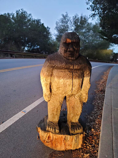
Uncredited - hogp, Scotts Valley Police DepartmentIn this photo provided by the Scotts Valley Police Department is a figure of Bigfoot that officers found on a roadway in the mountains north of Santa Cruz in Scotts Valley, Calif., Thursday, Nov. 12, 2020. The Scotts Valley Police Department says it was a little banged up but will be returned to its rightful place at the Bigfoot Discovery Museum. The Santa Cruz County Sheriff's Office had urged people to keep their eyes peeled for the 4-foot-tall wooden statue after it was stolen from outside the tiny museum in nearby Felton on Monday.
Some unexpected spots might see a white Christmas this year.
It might be normal in the North, but places as far south as the Tennessee Valley could wake up to snow on Christmas morning. Chattanooga and Knoxville, Tennessee; Asheville, North Carolina; and the North Georgia Mountains could also get some. Higher elevations will get more accumulation, but places like Knoxville, which will most likely have snow Christmas Eve, historically has only a 3% chance of a white Christmas.
This is all part of a larger storm system that is strengthening and could cause major problems all across the Eastern Seaboard.
Snow and strong winds created blizzard conditions across portions of the Dakotas and Nebraska on Wednesday. The snow will continue Wednesday evening across the Upper Midwest with white-out conditions likely. Blizzard warnings and winter storm warnings remain in place until early Thursday.
“Winds could gust as high as 60 mph, causing significantly reduced visibilities in blowing snow,” according to the National Weather Service.
As the storm moves east, it will be mainly a rainmaker. Christmas Eve will be wet for millions from Upstate New York to the Florida Panhandle. There could even be some severe storms.
“Last-minute shoppers need to be on the lookout for quick-moving storms,” says CNN meteorologist Gene Norman. “This storm setup could easily allow for dangerous winds and even a few brief isolated tornadoes. Especially at risk on Christmas Eve are eastern sections of North and South Carolina, southern Georgia and Alabama, and parts of the Florida Panhandle.
From the Ohio Valley down to the Tennessee Valley, rain will switch to snow Thursday afternoon. Much of West Virginia and Eastern Ohio could see 3-5 inches of snow, with higher elevations seeing even more.
For the big cities in the Northeast, the expected rain causes concern for places that already have snow on the ground. In New York, Binghamton’s National Weather Service office has warned residents, “Where recent heavy snow fell, this could add weight to old snowpack on roofs/structures resulting in collapsed structures.”
Heavy rain following snow can also cause rapid melting and flooding.
The storm will clear out for most by morning, leaving a cold and windy Christmas across the South, but parts of the northeast will be rather warm. “Boston has a forecast high in the mid 50s Friday, which is not only 10 degrees above normal, but also means that Christmas Day will be warmer than Halloween was in Beantown, says CNN Meteorologist Allison Chinchar.
Millions are traveling despite the pandemic
Even though Covid-19 numbers are at their highest, people are still traveling by air. The Transportation Security Administration said Monday that it screened more than a million people at airport security for the third day in a row, which is a first during the pandemic. The TSA says, “1,064,629 people passed through checkpoints nationwide on Sunday.” This means 3.2 million people flew in three days.
Thursday, the delays will be felt in the entire Southeast due to rainfall. This includes New Orleans, Jackson, Mississippi, and Atlanta. Delays for snow will be in places like Knoxville, Cleveland and Pittsburgh.
Travel delays are expected across Southern California during the next few days as powerful Santa Ana winds continue into Thursday. For L.A. and Ventura Counties, winds will gust 40-60 mph with low humidity. This will increase the fire potential exponentially and cause growth to existing fires.